 |
Enchanted Forest Nature Sanctuary 444 Columbia Blvd., Titusville Florida 32780 |

|
Imagine yourself living in eastern Florida over 150 years ago -- say around 1837. It would have looked very much like most of what you see, today, in Titusville's Enchanted Forest Sanctuary -- similar terrain and many of the same types of plants and animals, and very few signs of civilization.
Imagine that you were requested by the U.S. Army to build a road through such a wilderness:
- The Territory of Florida was recently ceded from Spain (1821); statehood was almost 8 years off (1845).
- There were very few people living between New Smyrna and Key West; most of those were Seminole Indians who were being pushed deeper and deeper into the Everglades; most of the European and American settlers had recently been burned out and run off by the Seminoles, precipitating the Second Seminole War (1835-1842).
- There were no wagon roads, railroads, or intracoastal waterway; movement of people and freight into southeastern Florida was limited to Indian trails, the St. Johns River, or the Atlantic Ocean; but trails were barely wide enough for single file pedestrian traffic, the St. Johns River only provided passage to the Lake Monroe/Fort Mellon (aka Sanford) area, and the Atlantic coast had very few inlets and was very vulnerable to enemy ships based in the Caribbean region.
- The first road from St. Augustine to the Ft. Pierce area.
- A road at least 16 feet wide, for mule wagons and ox carts, and over 200 miles long.
- A road to connect forts, on behalf of the effort to remove the Seminole Indians, and eventually to support colonization of southern Florida.
Joseph M. Hernandez (1792-1857), a life-long resident of the St. Augustine area, and a Brigadier General in the Army, was given just such an assignment (Dec., 1837). Not only did he have to build the road without benefit of any heavy duty roadbuilding equipment (other than the hand tools used by his soldiers), but his task was conducted during the Second Seminole War, and ever closer to the heart of Seminole territory, as he worked his way southward. Although it was built during the winter months, thus minimizing problems with hot, humid weather and malaria-carrying mosquitoes, construction of the road must have been quite a challenge for General Hernandez' men, especially with the ever-present concern with attacks from Indians and/or wild animals (eg., alligators, panthers).
Most of the road was built along the prehistoric dune line known to geologists as the Atlantic Coastal Ridge -- relatively high and dry terrain, within a mile or so, west of present-day U.S. Highway #1. The same road had been blazed, and at least partially cleared, about 12 years earlier, by Col. James Gadsden's troops, as far south as the St. Lucie River. Hernandez took it to Fort Capron, near that river. Gadsden and Hernandez both probably followed the same trail used by the Seminoles for over a century, and by generations of native Ais and Timucuan Indians prior to that, as they traveled north and south, by horse or on foot, along the Rio de Ais -- now known as the Indian River.
This road was not really used very much by the military after 1838. And the first group to colonize the Indian River area, sailed directly in from the Atlantic Ocean, via the Indian River Inlet, settling in the St. Lucie/ Ft. Pierce area (1842). However, it was not long before many immigrants were also using the Hernandez Trail -- aka, on various maps, as the Capron Trail and the Hernandez-Capron Trail -- to reach their new homesteads.
With the opening of the Haulover Canal (1854) and the subsequent increase in river traffic, followed by the development of railroads (1880s-1890s) and then paved highways (20th century), human traffic on the Hernandez Trail diminished considerably. However, it was often used to drive cattle to market, even as recently as the 1940s. Some portions of the trail are still visible on aerial photos (and in some cases trail markers/monuments are visible on the ground), throughout Brevard County and Indian River County; but the trail segment that probably most resembles the original trail is to be found in the Enchanted Forest Sanctuary. If you would like to know more about it, contact one of the Friends of the Enchanted Forest, or read the following :
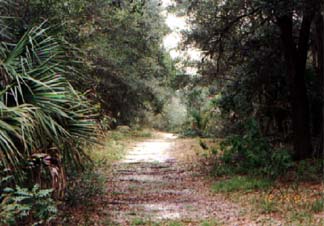 The Hernandez Trail in the Enchanted Forest December, 1996. |
 Click to enlarge. Cocoa Village, King St. (SR 520), just east of U.S. 1. |
 Click to enlarge. Marker at Airport Road and North Dixie Ave., Titusville |


| |||||||||
| |||||||||
|
• HOME
|
Keeping you up-to-date with what is available and what is going on in the Titusville, FL area. |
Contact the webmaster for most anything by CLICKING HERE |
|||||||
| the North Brevard Area | |||||||||
|
Produced by Peak Performance Co. nbbdcom@gmail.com Last updated: 5/12/18 — © 1996 - 2016 |
|||||||||
|
• Info on participating in this directory.
• Info for non-profits. • We can register, produce, host and market your Internet presence. |
|||||||||

EYES ON PAGE is what you seek when promoting your business or activity. In 2017 the webpages of the NBBD were visited 1,078,946 times - that averages 2,956 times a day. Won't some of them be seeking what you offer?
|
|||||||||